|
Spacial Focus:
About the system:
|
|
COSEM - COntaminant Spread in the Eastern Mediterranean
SELIPS: South Eastern Levantine Israeli Prediction System
Model description
|
SELIPS is a forecasting system meant to produce daily forecasts
of temperature, salinity and sea currents in the coastal zone of the
south eastern corner of the
Levantine Basin.
SELIPS is based on:
- POM: a 3D numeriacl model for the simulation of ocean dynamics.
- VIFOP: a software package used in SELIPS to reduce the amplitude of numerical waves created during the initialization proccess.
SELIPS is one way nested to ALERMO ( which is nested in turn to MFS ) and forced by the SKIRON atmospheric model.
The development of SELIPS begun with the MFSPP project and continued through the MFSTEP and ECOOP projects. SELIPS is run as part of title="Mediterranean Forecasting System Pilot Project">MFSPP project and continued through the MFSTEP and ECOOP projects. SELIPS is run as part of MONGOOS.
|
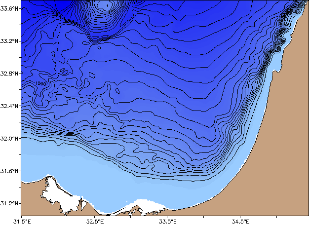 Model Bathymetry
|
| Model Domain |
East of 31.5°E
South of 33.7°N |
| Horizontal Resolution |
0.01°E x 0.00833°N (roughly 950m) |
| Vertical Grid |
27 sigma layers |
| Forecast Renge |
96 hours starting from 12:00 GMT |
| Initial Condition |
The POM model starts from an ALERMO forecast dataset, optimized by VIFOP. The initialization process is described below |
| Boundary Condition |
Fields of temperature, salinity water current and sea level elevation are taken from ALERMO forecast and used as open radiative boundary conditions. |
| Atmospheric Forcing |
Fields of air temperature, specific humidity, air pressure, wind, total cloud cover and precipitation from SKIRON 0.05° forecasts are used to calculate heat, shortwave radiation, fresh water and momentum fluxes for POM |
| Assimilated Data |
SST through Atmospheric fluxes correction. the product of Copernicus is being used. |
|
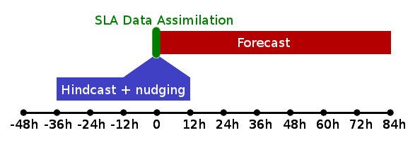
Initialization
|
the model is initialized from the ALERMO first day forecasts datasets which are interpolated and optimized using VIFOP.
The resulting temperature, salinity , velocity and elevation fields are used to initialize POM for a 2 day hindcast run.
The averaged fields of the last day of the hindcast are either used as the prior for the data assimilation process or as
initial condition to the forecast.
|
|
Assimilation of satellite altimetry
to be added later
|